
Andrew Durnford
1769 Obtained commission in the Royal Engineers 28 July 1769
1770 Assistant Commissary to superintend the demolition of the fortifications and canal
of Dunkirk, according to the Treaty of 1763
of Dunkirk, according to the Treaty of 1763
He was selected for this office from
his well known talents as a draftsman and engineer, having been employed for
some years at the Tower under Colonel Desmaretz. Also working with Andrew was Andrew Frazer.
Wikipedia advise that Andrew Frazer wrote a book Historical Description of the Town and Port of Dunkirk from the year 646 to 1768. (currently in Cambridge University there was a foreword to the front of the book, which reads "Dedicated to Sir Charles Frederick KB, surveyor-general of the ordinance, "from his most obedient and devoted humble servant, Andrew Durnford Engineer.""***
1772 Andrew wrote about an epidemic on board a Dutch East India ship of 60 guns in the Straits of Calais 6 March 1772
1772 31 March - This time he was reporting the doggers and fishing boats sailing from Dunkirk to the cod fisheries off the coasts of Iceland and Newfoundland. The traders were selling the goods to the English smugglers here in Calais, mentions of tea and also gin, which is the spirit most smuggled into England. There were always about 12 or 15 Irish wherries around the area, small boats go out and then offload the cargo
1772 7 April - Concerns about Chateau Trompette in Bordeaux which is to be demolished.
1772 Andrew wrote to John Robinson, concerning the smuggling of Irish wherries with an
account of Captain Conner, alias Batchelor or the Commodore. March 31 1772
account of Captain Conner, alias Batchelor or the Commodore. March 31 1772
 |
| Old Map of Plymouth |
1774 Worked on the defences at Plymouth 1774 - 1776
1776 American War of Independence as Deputy Assistant Quartermaster-General in Georgia
and West Florida
and West Florida
1777 He witnessed and reported on the battle at Peekshill in New York State
1779 AQG in New York
1780 Deputy Assistant Quartermaster-General in Georgia and West
Florida
(to his brother Elias) 26/5/1780 - 4/6/1783
(to his brother Elias) 26/5/1780 - 4/6/1783
Worked
on an anchorage north of St George's Island and on the Forts at Fort
Devonshire
Fort Poople and Fort St Catherine.
Governor Popple energetically fortified the island by repairing the existing defenses and built new forts including the small fort at Little Head, St. David's which was named Fort Popple in his honour. The fort was repaired by Captain Andrew Durnford in 1793 In 1793, Captain Andrew Durnford strengthened the battery at St. Catherine's Point and built a new battery with a guardhouse on the hill behind the fort
1783. Captain Andrew Durnford, Royal Engineers, wrote his
"Bermuda Defence
Report" of that year: "To the unequal distribution of that carbonate of lime in solution I
attribute, not only the caverns and sandflaws, but the pinnacle The most remarkable
groups are at Tobacco Bay, St. George's Island, and at the North Rock
Report" of that year: "To the unequal distribution of that carbonate of lime in solution I
attribute, not only the caverns and sandflaws, but the pinnacle The most remarkable
groups are at Tobacco Bay, St. George's Island, and at the North Rock
1784 Chief Engineer at Chatham rank of Captain Lieutenant 1785 - 1787
1788 Fortify the forts of Bermuda, promoted to the rank of Captain
and later Major, first British engineer to work Bermuda.
1788. The Royal
Engineers arrived in Bermuda from Britain to begin the refortification of the
islands. Worked on layout of defences. Andrew Frazer also worked on the same forts at the same time.
The forts at Bermuda number more than 90 and the fortifications account for a large proportion of heritage listings in Bermuda. The works of Andrew Durnford R.E. at the Martello Tower, Fort Cunningham, Alexandra Battery and artillery structures of Fort Victoria
The forts at Bermuda number more than 90 and the fortifications account for a large proportion of heritage listings in Bermuda. The works of Andrew Durnford R.E. at the Martello Tower, Fort Cunningham, Alexandra Battery and artillery structures of Fort Victoria
1788.
Major Andrew Durnford was one of the officers who arrived from England.
 He re-built Paget Fort
 He re-built Paget Fort
Around 1740, governor Alured Popple made major repair work and mounted
10 guns on the fort. In 1746, there were so many prisoners of the war
who had to be brought into Bermuda that the only place they could be
accommodated was here in Paget Fort. The fort was damaged by a severe sea storm in 1791 and had to be
rebuilt. Several reconstruction and renovation took place, and finally
the Fort Cunningham came up in 1875 that replaced the old Paget Fort. It
was named after Captain Thomas Cunningham who was from the British
Royal Engineers and supervised the construction of the fort.
1793 With the threat of war with France, the Governor of Bermuda directed Major
Andrew Durnford to
build a new Barbette Battery on the height of the land above Paget Fort on
Paget Island
1793. June 29. the Town of St. George, first
established in 1612, was officially incorporated by Act of Parliament and
received its first Mayor, Major Andrew Durnford
1796 Suspended for corruption - diverting funds to build Queens
Warehouse and a house in St George Town where he was the first Mayor
1798. September 1.
Recording of Last Will and Testament re his Bermuda Property
1798 Died in Bermuda
1798. September 10. Death
in St. George's, from Yellow Fever, of Major Andrew Durnford, Royal Engineers, and former Mayor of St. George's.
The relationships between Andrew Frazer and his wife's grandfather John Peter Desmaretz, and Andrew Durnford, cross in many fields as does that of Stillingfleet Durnford, who was in the Office, and that of Desmaretz Durnford, whose records and achievements were attributed to Andrew.
They all worked at Dunkirk, they trained and were taught, at the Office of Ordinance, both Andrews were in West Indies at the same time!
***Lt Col Andrew Frazer FRSE (sometimes spelt Fraser; died 1792), was a Scottish soldier and engineer. He served as lieutenant-colonel of engineers, designing and superintending the construction of Fort George. He was the architect of St Andrew's Church, on George Street, Edinburgh.

 |
| Letters re Dunkirk |
The relationships between Andrew Frazer and his wife's grandfather John Peter Desmaretz, and Andrew Durnford, cross in many fields as does that of Stillingfleet Durnford, who was in the Office, and that of Desmaretz Durnford, whose records and achievements were attributed to Andrew.
They all worked at Dunkirk, they trained and were taught, at the Office of Ordinance, both Andrews were in West Indies at the same time!
***Lt Col Andrew Frazer FRSE (sometimes spelt Fraser; died 1792), was a Scottish soldier and engineer. He served as lieutenant-colonel of engineers, designing and superintending the construction of Fort George. He was the architect of St Andrew's Church, on George Street, Edinburgh.
Life
Frazer was the son of George Frazer, a deputy surveyor of excise in Scotland, was probably employed on the works at Fort George after the Scottish rebellion of 1745–6.
Andrew was appointed practitioner engineer, with rank of ensign in the train, on 17 March 1759, and sub-engineer, with rank of lieutenant, in 1761. In 1763 he was ordered to Dunkirk, and served as assistant to Colonel Desmaretz, the British commissary appointed to watch the demolition of the works of that port in accordance with treaty obligations. On 18 October 1767 he succeeded Desmaretz in that office, and retained it until the rupture with France in 1778. In the British Museum MSS are two reports from Frazer: ‘A Description of Dunkirk,’ 1769, and ‘Report and Plans of Dunkirk,’ 1772. A letter from Frazer to Lord Stormont, British ambassador at Paris in 1777 (ib. 24164, f. 172), indicates that he discharged consular functions at Dunkirk. He became engineer in ordinary and captain in 1772, brevet-major in 1782, and regimental lieutenant-colonel in 1788. He designed St. Andrew's parochial church, Edinburgh, built in 1785.
In 1773 he married Charlotte Durnford, daughter of Stillingfleet Durnford, of the engineer department, and granddaughter of Colonel Desmaretz; by her he was father of Sir Augustus Simon Frazer.
In 1783 he was a founding fellow of the Royal Society of Edinburgh.At this time his address is given simply as George Street, Edinburgh.
He died en route to Geneva on 31 August 1792.
However from the Catalogue of Rare and Valuable Books for sale by Thomas Boon, clearly it states that Engineer Andrew Durnford wrote the book.

 John Peter Desmaretz had a sixty year career, mapping and fortifying
most of the south east coast of England. He was surveyor, engineer and
architect all rolled into one and his output was prodigious.
John Peter Desmaretz had a sixty year career, mapping and fortifying
most of the south east coast of England. He was surveyor, engineer and
architect all rolled into one and his output was prodigious.He spent a large part of his career working in Portsmouth dockyard where he drew up numerous plans for the dockyard, town and defences.
This map of 1744 gives an excellent idea of the scale of fortifications for Portsmouth.
Note the Gun Wharf, separate from the fortified town itself. The Victuallers Key for supplies to be brought in and the staple diet of many a poor family living on the coast oysters, represented by Oyster Street.
Desmaretz himself was buried in the Garrison Church where his epitaph gives a glimpse of his possible origins, it has been suggested that he may have been a Hugenot.
(Plymouth was also the home of the Prison hulks, where prisoners were kept, prior to leaving for the Colonies)
As the Royal Navy increased its military capacity and imperial duties so it moved into the realm of science to keep it at the cutting edge of military technology, exploration and imperial expansion.
Sailors like Captain Cook and Tobias Furneaux set off from Plymouth to map the world, chart the stars and find suitable anchorages and refuelling stops for the ships of the Royal Navy. Cook left from Plymouth in 1768 on the Endeavour.
In 1772 he set off from Plymouth on his second voyage on the Resolution. This voyage nearly came to grief before it began when the ship was nearly foundered on the rocks below the Citadel.

William Bligh was given the mission of moving breadfruit from Tahiti to the Caribbean so that the plantations there might find a more efficient foodstuff for their workers and slaves. The Royal Navy had gone beyond being a mere military arm and its base at Plymouth was the perfect launch pad for its expanding scientific horizons.
Artists and Botanists were also attached to ships as they travelled the world looking for new species or commercial activities that the British economy could get a head start on. The most famous of these would be Charles Darwin who sailed from Plymouth on a five year voyage in 1831. This voyage would form the foundation for his theory of evolution and showed just how far the Admiralty was prepared to go in subsidizing the pursuit of knowledge and a better understanding of the world.
The near foundering of Cook's
ship the Resolution on the rocks below the Citadel in 1772 was no
isolated event. The sharp South Westerly winds could whip up powerful waves
that made it difficult for ships to leave the anchorage safely. It was
particularly difficult on the Cattewatter and Sutton harbour which was more
exposed than the Hamoaze. However, ships leaving the Hamoaze still had to
follow a deep water channel the long way around Drake's Island which could
expose them to the harsh winds. In an age of sail, the constant tacking and
changing of direction could be a cumbersome process on entering or leaving the
Sound. If the winds were too strong, it was impossible to leave the anchorage
at all.
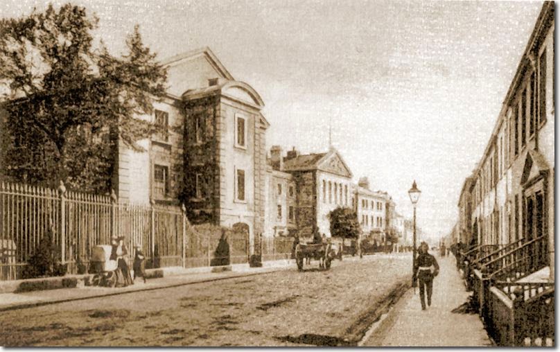
Durnford
Street was the main thoroughfare of Stonehouse, the smallest of the three
towns. It was where the well to do were based but it also developed significant
military infrastructure of its own. Here you can see the Royal Marine
Barracks's Entrance opening out onto Durnford Street.

At Stonehouse the Royal Navy had completed a new hospital in 1762 and a few years later the bridge across Stonehouse Creek was built, thus giving easy access to Plymouth Dock. Stonehouse seemed like an ideal place for a barracks and a site close to Mill Bay was chosen. There was only one other building in the vicinity, the Longroom, which was a popular location for balls and other forms of entertainment.
The barracks were started in 1781 on land bought from Lord Mount Edgcumbe. The design followed a pattern used elsewhere in Britain, notably Chatham, and comprised three accommodation blocks around a parade ground. The fourth side, to the west, consisted of only the Guardroom, the parade ground being separated from Barrack Street by railings. The north block accommodated the junior officers, the south block was home to the senior officers, while the men and NCOs were housed in the much larger east block. The Commandant's residence was at one end of the south block. The barracks were first occupied in 1783.
(Stonehouse and the lands, were owned by the Durnford family from Cornwall!
No comments:
Post a Comment